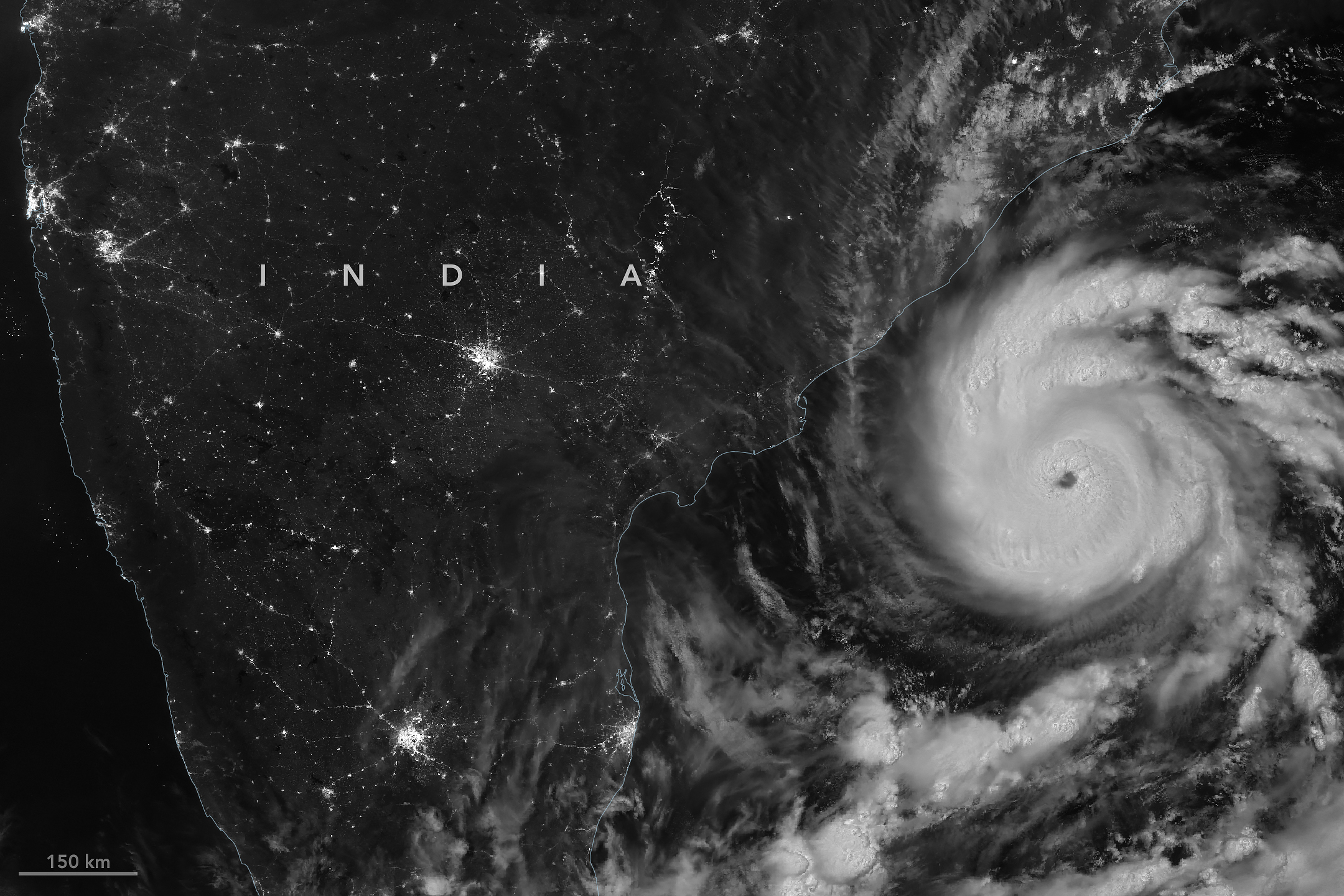
The first named storm of the 2026 North Indian Ocean cyclone season—Arnab (pronounced Or-nab)—emerged in the Bay of Bengal on October 25, a rather late start for a basin that typically produces named cyclones in April or May.
When the VIIRS (Visible Infrared Imaging Radiometer Suite) on NOAA-20 captured this nighttime image at 20:12 Universal Time on October 26 (1:42 a.m. India Standard Time on October 27), the storm had sustained winds of about 140 kilometers (85 miles) per hour, according to the India Meteorological Department (IMD).
When Arnab made landfall on the Andhra Pradesh and Yanam coast early on October 28, sustained winds were 130 kilometers per hour. IMD categorizes a storm that strength as a “very severe cyclonic storm,” which is similar to a Category 1 storm on the Saffir-Simpson hurricane wind scale. It made landfall between Bapatla and Visakhapatnam, a heavily settled area home to large cities, farmland, and fishing communities.
Arnab caused extensive damage, uprooting trees, inundating crops and homes, limiting fishing operations, and disrupting transportation and power networks, according to news reports. Prior to landfall, Indian authorities had evacuated tens of thousands of people from vulnerable coastal areas.
The storm comes in the midst of an El Niño, a climate pattern marked by warmer-than-normal water temperatures in parts of the equatorial Pacific that emerges roughly every two to seven years. The changed ocean conditions can influence the atmosphere in ways that alter global weather patterns and change the distribution of rainfall, winds, tropical cyclones, fires, floods, and other phenomena.
In the Bay of Bengal, for instance, some research indicates that altered environmental conditions during an El Niño are associated with a reduction in tropical cyclone activity. The ocean basin sees both less frequent and less intense tropical cyclones during El Niño years, researchers have found.
NASA Earth Observatory image by Michala Garrison, using VIIRS day-night band data from NASA EOSDIS LANCE, GIBS/Worldview, and the Joint Polar Satellite System (JPSS). Story by Adam Voiland.
References & Resources
- Associated Press (2026, October 28) Cyclone batters India’s eastern coast, killing 3 and damaging homes and farmland. Accessed October 28, 2026.
- Bhardwaj, P., et al. (2019) Tropical cyclone activity over Bay of Bengal in relation to El Niño-Southern Oscillation. International Journal of Climatology, 39(14), 5452-5469.
- Colorado State University (2026) Current Season North Indian Ocean (1991-2020 Climatology). Accessed October 28, 2026.
- The Hindu (2026, October 28) Cyclone Arnab’s landfall process continues along Andhra coast. Accessed October 28, 2026
- The Indian Express (2026, October 28) Cyclone Arnab hits Andhra coast; over 84,000 people moved to shelters. Accessed October 28, 2026.
- India Meteorological Department (2026) National Bulletin. Accessed October 28, 2026.
You may also be interested in:
Stay up-to-date with the latest content from NASA as we explore the universe and discover more about our home planet.
Several ingredients came together off the Pacific coast of Mexico to generate one of the strongest storms the eastern Pacific…
The powerful storm delivered extreme rainfall and damaging winds to the state, passing the Island of Hawaiʻi as a category…
Hurricanes Polo and Nolo sent destructive effects ashore amid an active season in the northeastern and central Pacific.




Source: science.nasa.gov